Land Xplorer GNSS RTK
Reliable centimeter-level
for high precision mapping
14mm + 1ppm
With NTRIP network Data Link and external antenna

184 Channels
GPS | GLONASS | BeiDou | Galileo | QZSS | SBAS
The most cost-effective
All in One Solution
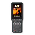
- Rugged Data Collector
- Powerfull Software
- Accurate RTK GNSS Receiver
- Rear Camera 16M / Front Camera 8M
- 9000mAh Lothium-ion battery all-day run time, field-replaceable.
- IP67 / MIL-STD-810H guaranteed and CE FCC ERP RoHS certificated.

Accessories included

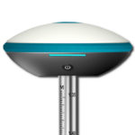
GNSS UFO External Antenna
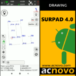
SurPad 4.0 has developed an advanced technology for GNSS and TS measures, specially on Point Survey and Stakeout, Road Design and Stakeout, Cross Section, Electric Lines, Pipe Lines and much more.

Small & Flexible 360 Helix antenna
Multi-Constellation GPS, GLONASS, BeiDou, Galileo and SBAS tracking satellite signals.
ultra-small size and lightweight, ideal for many types of applications.

Magnetic Base Antenna Adapter
The base can be firmly attached to the iron object, antenna can be safely mounted outside the vehicle for tracking and surveying. 5/8-11 thread.

Metal Cradle for Pole
This accessory makes it easy and safe to hold the Landxplorer while doing your fieldwork.
Surpad 4.2 software
Land Xplorer includes Surpad 4 software for Android, with activated permanent license.
This powerful tool for field measurements has a very extensive and easy-to-use application package, which will allow you to carry out your field and office work efficiently.

New GNSS Generation
RTK
ACNOVO LAND XPLORER
Support L-Band function, you can get centimeter accuracy just with one receiver.
Rugged Design
Shock and vibration resistant characteristics. IP67 certification ensures operation in various of tough environments.

Surpad 4.0 Software
SurPad 4.0 has developed an advanced technology for GNSS and TS measures, specially on Point Survey and Stakeout, Road Design and Stakeout, Cross Section, Electric Lines, Pipe Lines and much more.

Highly integrated internal components
The innovative technology made Land Xplorer GNSS RTK has excellent combination with GNSS, 4G, Bluetooth and Wi-Fi antenna, which reduces the internal signals crosstalk.
4G Network
Mobile Internet
Land Xplorer GNSS RTK with its advanced 4G module, high speed stable internet, guarantee 4G network can transmit world-widely.

Wi-Fi connection
The most widely exchange data used in the world.
Stable data transmission with these useful and fast connecting ways.

V4.2 Bluetooth
Full Speed Bluetooth for data. Exceptional performance will allow users to connect at highter distance and low energy standards.

9000mAh Battery
15 hours of continuous work, makes the equipment very light, very important for long days of work.
High Performance
Land Xplorer GNSS RTK with advanced satellite tracking technology ensures it works well even in harsh environment such as under heavy foliage, advanced software with hi performance can search available satellites and get Fixed solution quickly.

MIL-STD 810 G and IP67 Certified
Environmental design for strong weather conditions, protection against water and dust.

16 MP Camera with Autofocus
16 megapixel rear camera and 9 megapixel front camera.

Touch Panel
Capacitive screen, support glove/wet hand.
What accuracy can you expect from the Acnovo Land Xplorer receiver?
The following table is a comparison of results between points collected with our Acnovo receivers GX1 GNSS RTK and Land Xplorer GNSS RTK vs high-end receivers (including others brands) under the same conditions. NTRIP data link mode with single base (no VRS).
The averages in this table were made using only data from high-end equipment, which come from 10 points collected directly in the field with the Surpad 4.2 software.
All the measurements were made under adverse circumstances, to simulate the most realistic conditions, cloudy environment with rain, in all cases the measurements were made with data from a cold start.
| Place | Base Dist. | Device | Northing | Easting | Delta Nort | Delta East |
| Zone 1 | 5 km | Acnovo GX900 | 1130911,784 | 662291,981 | -0,013 | 0,002 |
| Stonex S800 | 1130911,758 | 662291,983 | 0,013 | 0,000 | ||
| South G7 | 1130911,772 | 662291,984 | -0,001 | -0,001 | ||
| Average | 1130911,771 | 662291,983 | ||||
| Land Xplorer | 1130911,768 | 662291,994 | 0,003 | -0,011 | ||
| Acnovo GX1 | 1130911,760 | 662291,975 | 0,011 | 0,008 | ||
| Place | Base Dist. | Device | Northing | Easting | Delta Nort | Delta East |
| Zone 2 | 10 km | Acnovo GX900 | 1132574,943 | 656971,329 | 0,002 | 0,021 |
| Stonex S800 | 1132574,943 | 656971,372 | 0,002 | -0,022 | ||
| South G7 | 1132574,948 | 656971,348 | -0,003 | 0,002 | ||
| Average | 1132574,945 | 656971,350 | ||||
| Land Xplorer | 1132574,934 | 656971,363 | 0,011 | -0,013 | ||
| Acnovo GX1 | 1132574,940 | 656971,375 | 0,005 | -0,025 | ||
| Place | Base Dist. | Device | Northing | Easting | Delta Nort | Delta East |
| Zone 3 | 16 km | Acnovo GX900 | 1134734,553 | 651846,531 | 0,001 | 0,000 |
| Stonex S800 | 1134734,610 | 651846,526 | -0,056 | 0,005 | ||
| South G7 | 1134734,500 | 651846,536 | 0,054 | -0,005 | ||
| Average | 1134734,554 | 651846,531 | ||||
| Land Xplorer | 1134734,512 | 651846,481 | 0,042 | 0,050 | ||
| Acnovo GX1 | 1134734,537 | 651846,552 | 0,017 | -0,021 | ||
| Place | Base Dist. | Device | Northing | Easting | Delta Nort | Delta East |
| Zone 4 | 17 km | Acnovo GX900 | 1133481,715 | 650549,717 | 0,006 | 0,012 |
| South G7 | 1133481,727 | 650549,742 | -0,006 | -0,013 | ||
| Stonex S800 | N/D | N/D | ||||
| Average | 1133481,721 | 650549,730 | ||||
| Land Xplorer | 1133481,694 | 650549,752 | 0,027 | -0,023 | ||
| Acnovo GX1 | 1133481,718 | 650549,756 | 0,003 | -0,027 | ||
| Place | Base Dist. | Device | Northing | Easting | Delta Nort | Delta East |
| Zone 5 | 20 km | Acnovo GX900 | 1138962,705 | 650025,710 | -0,009 | 0,027 |
| Stonex S800 | 1138962,693 | 650025,746 | 0,003 | -0,009 | ||
| South G7 | 1138962,691 | 650025,756 | 0,005 | -0,019 | ||
| Average | 1138962,696 | 650025,737 | ||||
| Land Xplorer | 1138962,687 | 650025,693 | 0,009 | 0,044 | ||
| Acnovo GX1 | 1138962,669 | 650025,781 | 0,027 | -0,044 |
Land Xplorer GNSS RTK + external antenna
Technical Specifications
Performance
CPU
H:Qualcomm 8953 2.2GHz
OS
Android 10
RAM
4GB
Extension
Micro SD card, up to 512 GB
Rear Camera
16M
Front Camera
8M
Battery
9000mAh
Battery Working TIme
15hrs
Physical
Size
237mm*144mm*144mm
LCD
8″ HD 1280*800 500Nits (Sunlight readable)
Touch Panel
Capacitive screen, support glove/wet hand
Flash Light
Y
Microphone
Y
Speaker
2.0 W, waterproof
Weight
660g
Voltage
5V, 2A
IKeypad
Power, Volume, F1, F2
Communication
WIFI
802.11 a/b/g/n/ac, 2.4GHz/5GHz
SIM CARD
Dual SIM & Dual standby
Network
GSM:850/900/1800/1900
WCDMA: B1/B2/B5/B8
TDD – LTE:Band1/Band2/Band3/Band4/Band5/Band6/Band7/Band8/Band17/Band20/Band28
Bluetooth
BT 4.2
USB
Type C
External Interface
USB, UART, GPIO
Support Protocols
Ntrip
GNSS Overview
ChannelsChannels
184-channel
Satellite Tracking
-GPS: L1/A L2C, GLO L1OF L2OF
-BeiDou: E1B/C E5B, BDS B1I B2I
-GLONASS: L1, L2
-Galileo: EB1/C E5b, BDS B1I B2I
-QZSS: L1C/A L1S L2C, SBAS L1C/A
-SBAS: L1, L5
Nav. update rate
RTK up to 20 Hz1
Position accuracy
RTK 0.01 m + 1 ppm CEP
Convergence time2
RTK < 10 sec
Sensors
NFC
Y
G Sensor
Y
Gyroscope
Y
Light Sensor
Y
Compass
Y
2D scanner
Y
OTG
Y
Environmental
Work Temperature
-20 ~60
Storage Temperature
-30 ~70
Waterproof & Dustproof
IP67 MIL-STD-810H
Drop Test
1.2m drop
Humidity
95% no condensation
FCC, CE, RoHS