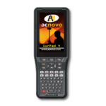
SURPAD 4 for Andorid
is a field software for GPS / GNSS receivers specially created to work on Android device.
Easy to operate thanks to its friendly graphical interface and intuitive design.
The current version of Surpad is the 4.2, this updated have a lot of improvements which make it one of the advanced software for mobile devices like phones and tablet.
Comes with helpful measurement tools to increase the productivity of the most demanding positioning professionals at affordable price.
SPECIAL OFFER
SAVE 60 USD
USE THE COUPON CODE
>>> DISCOUNT80 <<<
Hurry up and don’t miss out on this limited time offer to get the most convenient field software for GNSS measurements with Android devices.

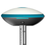
Compatibility With Multiple Brands and Models
You have a wide variety list of GNSS compatible receiver and Total Stations manufacturers, both robotic and conventional.
- Emlid Reach: RTK RS+, M+, RS2
- Geobox: RTK Fora20H, Fora20N, Fora20T, Fora20Fix2, Fora SMART, SMART-ST.
- Geodex: Total Station GET-122CR
- KQGEO: RTK M8, M8pro, M8mini
- Geneq: RTK F90, SXBlue Premier, SXBlue II+GNSS
- Beidou Halda: RTK TS3
- Foif: RTK, RTK A30, A90, N90, A60, A70 pro IMU, Total Station R2, 312R6
- Pentax: RTK G6 series, RTK G5
- Trimble: RTK R2 (need special activation code, please contact us)
- HuaXing: RTK A8, A10, A12, A16
- Topcon: RTK HyperVR (need special activation code, please contact us)
- Sokkia: RTK GCX2, GCX3 (need special activation code, please contact us)
- Hemisphere: RTK S321, S321+, S631, MG20.
- Hi-Target: RTK V8,V9, V30, V60, V90, V98, V100
- STONEX: RTK, M5/M5II, MG14, S86+, S9I, S9II, S9III, S800a, S900a
- Sanding: RTK, RTK-PSIC, Inertial, PDA, T9, T20T, T5 gnss, T7plus, (old models).
- GeoMax: RTK Z35, Z35Pro
- South: RTK Inertial, RTK-PSIC, PDA, S86+, S86T, S82V, Galaxy G1, Galaxy G3, Galaxy G7, Total Station KTS-400
- Ruide: RTK, RTK-PSIC, Inertial, PDA, R90, R6 (old models), Total Station KTS-400
- Kolida: RTK, Inertial, RTK-PSIC,PDA, K96T, K9TX, K5, Total Station KTS-400
- UniStrong: RTK MG20, UG905, G970ii, and others models.
- GINTEC: RTK F100, F90, G10, Total Station 120A
- Hisind: RTK H32, F60, iRTK2, iRTK5
- Ardusimple: simpleRTK2B, simpleRTK2B-F9P V3, simpleRTK2Blite RTK ZED-F9P
- SparkFun GPS RTK: Surveyor, Express ZED-F9P, NEO-M8P GPS RTK SMA Boards
- Geobox: Fora Lux
- Esurvey: E100, E200, E300 Pro, E600, E800 GNSS
- Muya: RTK M9
- Tianyu: South C6
- Other: RTK NMEA0183, internal GPS

Full Android Compatibility
All your Android devices can work to collect data with SurPad 4 software both controllers and tablets.
Cloud Service
This is a feature of SurPad 4.0 that allows simultaneous field and office work. Data can be uploaded and backed up quickly, greatly improving the efficiency of surveying.
Multiple Coordinate Systems
Surpad 4 comes with 1600 preset multi-country coordinate systems, projection mode, units, and file encoding scheme.
You can also share the coordinate system of your project with other users through a QR code.


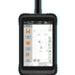
Location map
You can better visualize your topographic work on a local map: SurPad 4 shows on a base cartography, the points surveyed in their corresponding position and labeled for a better control of the work carried out.
In addition, the new CAD function in SurPad 4, allows you to draw graphics directly in field work. You can easily pick up points on an alignment.
Supports layer management, import and export of DXF and SHP files.
Simple and Elegant
Accurately record the data your project requires in an intuitive and friendly way.
Surpad4 is as easy to use as any application for your Android mobile.
Enjoy its graphic power in your field work and the multiple file formats to import and export in your projects.

Connect, Record, Calculate, Draw … All in One!


")
")
")

Quick Connections
SurPad 4.0 can connect receivers via Wi-Fi and Bluetooth.
Connect your equipment quickly and safely, no wiring required.
Quick connection can search and connect the device automatically, using wireless connections.
One Controller for all your surveying and geodetic equipment, at your fingertips:
As Simple To Use As Your Own Phone!

And More…
SurPad 4 is available in multiple languages. English, Chinese, Italiano, Le français, Português, Magyar, Türkçe, Ελληνικά, русский, Suomi, svenska, čeština, w języku polskim and more.
Every simple operation is accompanied by voice alerts, including instrument connection, fixed GPS positioning solution or stakeout.
SurPad 4 is equipped with a complete professional road design and stakeout function, so you can calculate complex road stakeout data easily.
Surpad 4 Quick Start Guide